이몰라 도시 지도 (Plan of Imola)
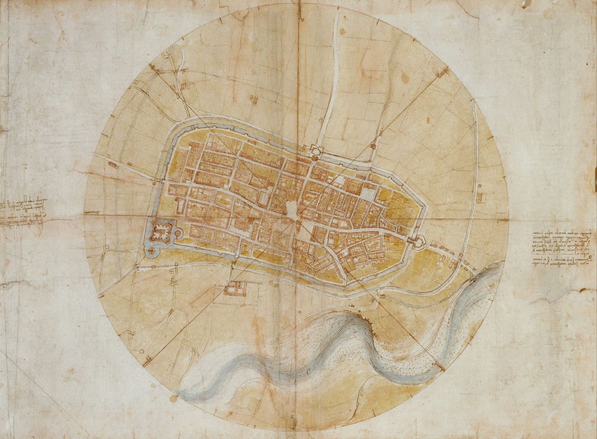
지적 정밀성과 근대 지도학의 시초를 증명하는 르네상스 과학 예술의 정수, <이몰라 도시 지도 (Plan of Imola)>입니다. 이 작품은 천재 거장 레오나르도 다 빈치(Leonardo da Vinci, 1452–1519)가 1502년경 완성한 희귀 지도학 유작으로, 실제 규격은 세로 44cm, 가로 60cm 크기이며 현재 영국 로열 컬렉션(Royal Collection Trust, Windsor Castle)에 보존되어 있습니다. 종이 위에 펜, 잉크, 수채 안료를 사용하여 이탈리아 이몰라(Imola) 도시 전체를 하늘에서 내려다본 수직 투시도(Ich nographic view) 방식으로 완벽하게 정립해 낸 지도 회화 명작입니다.
당대 유럽 지도 제작자들이 도시를 비스듬한 풍경화 형태로 그리던 관습에서 벗어나, 레오나르도는 완벽한 원형 방위각 프레임 속에 격자형 도로망, 성벽, 성채, 그리고 하단의 푸른 산테르노 강줄기까지 정확한 비율로 그려 넣었습니다. 중앙 정점을 기준으로 8개 방위선이 교차하는 원형 도식은 조형적 안정감과 수학적 명확성을 상징합니다. 성벽 내부의 구획된 주택들과 광장의 배치를 정교하게 채색하여, 도시라는 거대한 유기체를 과학적 정밀함과 예술적 아름다움으로 승화시켰습니다.
이 화폭에는 르네상스 군사사와 연관된 대담한 비하인드 스토리와 역사적 평가가 담겨 있습니다. 1502년 레오나르도는 악명 높은 교황의 아들이자 군주였던 체자레 보르자(Cesare Borgia)의 수석 군사 기획자 및 총괄 건축가로 임명되었습니다. 체자레 보르자가 이몰라 도시를 군사 요충지로 삼아 점령했을 때, 레오나르도는 방어 시설을 강화하고 포병대의 사격 범위를 정밀히 계산하기 위해 이 지도를 제작했습니다. 그는 거리마다 직접 발걸음으로 거리를 측정하고 각도를 계산하는 치밀함을 보였습니다. 현대 미술사학자와 과학사학자들은 이 도면을 인류 역사상 최초의 현대적 정수직 도시 지도 중 하나이자, 군사 공학과 정밀 수채화 기술이 결합된 인문주의 지리학의 기념비적 유산으로 평가합니다.
이 도면을 바라보는 감상자의 심리는 조용한 탐색적 정돈감을 경험하게 됩니다. 가장 먼저 중앙의 원형 프레임 교차점과 빽빽하게 짜여진 주황빛 도시 구획에 시선이 닿은 뒤, 서쪽 끝에 솟아 있는 단단한 이몰라 요새(Rocca Sforzesca)의 입체적 윤곽으로 흐릅니다. 이어 하단에 아치형으로 부드럽게 굽이치는 푸른 산테르노 강줄기를 따라 오른쪽으로 시선이 이동하며, 원형 테두리를 가로지르는 방위선과 여백의 거울 쓰기 메모를 거쳐 다시 중심부로 정갈하게 되돌아옵니다. 이러한 시각적 동선은 복잡한 마음을 차분히 가라앉혀 주며 내면의 명징한 평온을 선물합니다.
This masterpiece, titled Plan of Imola, was created around 1502 by the High Renaissance master Leonardo da Vinci (1452–1519). Measuring 44 cm in height by 60 cm in width, this exquisite map executed in pen, ink, and watercolor on paper is permanently preserved in the Royal Collection Trust at Windsor Castle, United Kingdom. Depicting an ichnographic, vertical overhead view of the town of Imola enclosed within a precise circular orientation wheel, the work stands as a monumental milestone in the history of cartography.
Departing from the conventional pictorial views of his contemporaries, Leonardo engineered a strictly measured plan centered on intersecting directional lines that indicate the eight principal winds. The drawing meticulously records every street, building block, defensive rampart, and the winding course of the Santerno River below. Through vibrant watercolors and refined line work, Leonardo transformed a functional military survey into a pristine geometric harmony that reflects the Renaissance ideal of structured urban order.
Fascinating historical context illuminates the origins of this celebrated sheet. In 1502, Leonardo entered the service of Cesare Borgia as Senior Military Architect and General Engineer. During Borgia's occupation of Imola, Leonardo surveyed the city on foot using a magnetic compass and odometers to evaluate fortification vulnerabilities and artillery angles. Today, cartographers and art historians universally revere this drawing as one of the earliest modern town plans in western history, praising its brilliant synthesis of empirical measurement, strategic utility, and elegant design.
Engaging with this technical masterpiece leads the viewer through a serene, measured visual journey. The eye is initially drawn to the dense, warm-toned grid of the town center where the orientation lines converge. The view then glides westward to inspect the sharp outlines of the fortified citadel, sweeps downward along the cool blue curves of the river, and traces the outer circular frame back to the central square. This ordered visual movement releases cognitive fatigue, offering a sense of quiet clarity and balanced composure.
본 리뷰에서 작품을 제외한 컨텐츠의 저작권은 팔렛트제주에 있습니다.
"퍼블릭도메인 고전명화"를 제외한 모든 창작 콘텐츠는 저작권법 제4조 및 제10조에 의거하여 보호됩니다. 무단 도용시 저작권법 제136조(벌칙)에 의거, 당사의 사전 서면 승인 없는 저작권 침해 행위를 금지합니다.